pariznoize
jul 02, 2003.
If you're not actually living in Paris or planning to do so in the near future and do not feel an urgent need to be guided along the tortuous paths of French bureaucracy, nor are you desperately looking for what to do when finding yourself in Paris and in need of disposing of a dead relative or friend, then there's probably not much reason for you to surf to www.paris.fr, the city of Paris's official website.
 |
If nevertheless one day you do chance upon the site, then look for the environemental tab and hit
the 'Lutte contre le bruit'-link.
'Lutte contre le bruit' should translate to something along the lines of 'War on Noise', or maybe rather 'Struggle against ...'
You'll hit upon a most curious archive, put online by the city's 'Observatoire du Bruit' - founded
in 1999 :: the 'Noise Observatory'.
One of the Observatory's tasks is mapping the city's noisescape, and identifying 'critical zones' - areas in which the population is exposed to extreme levels of 'sonic nuissance' (identified by levels >65dB at nighttime (22h-06h), >70dB during the day (06h-22h) -- meaning average levels, I suppose ...)
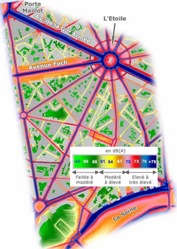
The Observatoire du Bruit decided to color the Parisian Street Plan, using a color scheme to indicate
average noise levels (ranging from bright green to stand for relative peace and quiet to darkish deep blue for raising hell).
... noise levels ... traffic noise levels ...
"There's about 3 million vehicles moving about daily along the 1.700 kilometers of roads and streets
covering the one hundred and five square kilometres of the Paris territory," it reads.
So the Observatoire du Bruit borrowed the figures of 'average daily traffic' for the years 1999 and 200,
as provided by the Direction de la Voirie et des Déplacements de la Ville de Paris, and started coloring maps.
I doubt that a single 'observer' has gone out into the city to actually listen.
But they're extremely good at coloring maps.
For their cartographie du bruit (routier moyen) the Noise Observatory cut up the region of Paris in
63 zones.
Then they produced 63 colored 2d-maps, indicating 'traffic noise' as experienced in the streets. (There's an example to the right, depicting part of the 16th arrondissement.)
Also they came up 4x63 3d-maps indicating 'traffic noise' as experienced at 'appartment level' [this might have involved some sort of academically approved algorithm, it might
also have been home-brewn]
4 maps : east-view, west-view, south-view, north-view -- yes! of course any one
should be able to identify his or her level!
315 maps.
Each and every one of them online.
Now pick your favorite random Parisian, explain to her the color-code.
Give her some pencils and a bw-map of her quarters.
Ask her to color that map.